January 3, 2001
Mud Yields Ghosts of Hudson River's Past
By KIRK JOHNSON
 |
 |
| Norman Y. Lono for The New York Times |
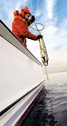
| Jay Ardai, an engineer on the Fletcher, measuring
the Hudson River's depth, temperature and conductivity. |
Related Articles
E.P.A.
Gives Its Plan on Hudson River PCB's, but a Fight Lies Ahead (Dec.
7, 2000)
Dredging
PCB's Could Be a Cure Worse Than the Disease, G.E. Insists (Dec. 7,
2000)
U.S.
to Order $490 Million River Cleanup by G.E.(Dec. 6, 2000)
On
Hudson, Cleanup Idea Stirs Emotions (Dec. 2, 2000)
In
War Over PCB's in Hudson, the E.P.A. Nears Its Rubicon (June 5, 2000)
The Natural
World: The Environment
Diagram
Clashing
Over the Cleanup (June 5, 2000)
Related Site
This site is not part of The New York Times on the Web,
and The Times has no control over its content or availability.
EPA Announces Its
Preferred Cleanup Plan
Map
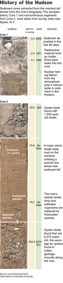
Core
Sample Sources on the Hudson
 |
| Hannah Fairfield/
The New York Times |
 |
| Norman Y. Lono for The New York Times |
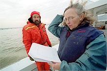
| Robin E. Bell, right, a scientist at Columbia
University, examining Hudson River temperature and salinity data collected
by Jay Ardai. |
|
 BOARD THE R. IAN FLETCHER, off
Nyack, N.Y. About a thousand years ago, a hurricane of cataclysmic proportions
swept up the Hudson River.
BOARD THE R. IAN FLETCHER, off
Nyack, N.Y. About a thousand years ago, a hurricane of cataclysmic proportions
swept up the Hudson River.
Or perhaps it was the mother of all northeasters. No one knows. What
is clear, however, is that the force of the storm was beyond any recorded
or remembered human experience. Great swaths of the river bottom were scraped
up and moved about in one ferocious flood.
Robin E. Bell, a senior research scientist at Columbia University, has
seen the storm in her imagination, and touched with her fingers the dense,
black-earth core drilling samples that reveal, in their banded marks, the
river's ancient trauma.
From the deck of the Fletcher, a 36-foot-long work boat that sails out
of Nyack, laden with computers and mini-cameras, sonar fish and salinity
meters, Dr. Bell and other scientists at Columbia and the State University
of New York at Stony Brook are mapping the Hudson from the bottom up, trying
to understand how the ghosts of the river's past, like the perfect storm
of A.D. 1000, might give clues about its future.
"It's about trying to find out these secrets, these time markers, so
that you can put everything together," she said on a recent cold, gray
day, as the boat bobbed gently on a slack tide just north of the Tappan
Zee Bridge.
Dr. Bell's mission, which is to build a complete model of the Hudson's
bottom using every high- tech tool of the information age, is revealing
things about the river that its murky waters have long kept veiled.
Huge natural reefs, made entirely of oyster shells, have been found
for the first time. The reefs, built by hundreds of generations of oysters
growing and dying and crumbling upon one another's backs, are at least
6,000 years old, predating the Great Pyramids. Sunken ships, one more than
150 feet long, that were long rumored or vaguely placed on shipping charts
have been pinpointed.
But perhaps the most startling findings are coming from the most humble
of sources: the river-bottom mud itself, which is giving up the secrets
of how, why and where it is deposited.
In December, the federal Environmental Protection Agency, citing its
own research about the properties of Hudson River mud, said that the General
Electric Company, which dumped toxic PCB's into the river from its factories
150 miles north of here, should be required to clean up the chemicals that
have become embedded in the sediment. It would be one of the largest and
most complex river cleanups in American history, with a price tag of $460
million in dredging costs alone.
General Electric's research, however, suggests that the PCB's are best
left where they are, entombed by successive layers of mud. The natural
containment of the chemicals, G.E. officials say, grows more secure with
every year and every new layer of silt.
Dr. Bell cautions that while her mapping project did not focus on the
areas proposed for dredging, the portrait of the river that is emerging
from her work suggests that both the government and the company are partly
right. Changes to the river bottom happen slowly, as G.E.'s research concludes,
with gradual and predictable new sediment layers piling one on top of another
in a layer cake effect. But that pattern can be suddenly torn apart by
an earthquake, a flood or some other environmental upheaval.
The evidence of such upheavals, Dr. Bell said, supports the E.P.A.'s
position that while the PCB's may be buried now, their escape into the
water will always be possible unless the chemicals are removed from the
sediment. PCB's, polychlorinated biphenyls, which were widely used as insulating
materials in electrical products until they were banned in the 1970's,
have been linked to cancer in humans and to other problems in wildlife.
"It's clear that there are storms that go through and erode sediments,"
Dr. Bell said. "Stuff moves."
A G.E. spokesman, Mark L. Behan, said that the upper Hudson is in many
ways a different river from the one being studied by Dr. Bell's group.
The area proposed for dredging a chain of PCB hot spots extending from
Troy to the company's old factories in Hudson Falls and Fort Edward is
marked by an interconnected system of dams and locks and canals that collectively
make the waters far more placid than they are to the south.
Recent studies by both the government and G.E. have suggested that floods
are more likely to add new sediment to that part of the river than take
it away, Mr. Behan said. The upper Hudson has largely been tamed.
Here to the south, especially on a blustery day, the Hudson still feels
like a wild place, even though New York City is only a few miles away and
the great span of the Tappan Zee Bridge dominates the horizon. Mergansers,
graceful ducklike birds that fish these waters, float quietly by, unperturbed
by the 39-degree temperature of the water. Fish of various sizes drift
under the boat.
Other wonders of the river, like the salt wedge, are invisible. The
salt wedge is the layer of ocean water that moves upriver with the tide.
Because it is denser than fresh water, the wedge slides underneath the
river's surface as it plows north, adding its own layer to the "cake."
But the salt layer also creates a band of turbulence that can distort a
sonar image, so it too must be understood so scientists can read the map
results.
This day's work mostly consists of measuring the depth and strength
of the salt current. Jay Ardai, an engineer-technician who hangs over the
stern in an orange survival suit, dips various instruments into the water
while Dr. Bell records the results. At the wheel, the Fletcher's captain,
John Lipscomb, keeps track of the boat on a global positioning screen so
that he can maneuver it for the next test.
The core drilling samples, like the salt wedge studies, are another
way to provide backup verification, or "ground truth," as it is called,
for the sonar images. But the cores also allow Dr. Bell to create a timeline
of the river's history.
Scientists analyzing the samples at Columbia's Lamont-Doherty Earth
Observatory in Palisades, N.Y., have identified a band of radioactive cesium
in the river mud. They say that the cesium marks the period of above-ground
nuclear testing in the 1950's and 1960's, a snapshot of the earth's atmosphere
taken by the river at that one moment in time and then sealed on the bottom.
Dr. Bell sees a giant historical tapestry in all this. She became enthralled
with geology when she learned about plate tectonics as a teenager and never
quite got over it, she said. Examining a core sample at the Lamont-Doherty
campus, she gently traces a finger down through the geologic record: a
shell deposited in the river around the time of Jesus, a band of gravel,
a compressed and preserved twig.
Now, standing on deck of the Fletcher named for a conservationist
who worked for many years with Riverkeeper, the boat's owner Dr. Bell
marvels at the ancient echoes of these waters. Since the Palisades on the
river's western bank in Rockland County rose up in a volcanic eruption
180 million years ago, she said, the Hudson has been a timeless constant
in the region. There are even different kinds of rocks on each side of
the river, she says.
Daniel Wolff, a writer from Nyack who has come out on several mapping
trips as a volunteer, stood near the stern, watching birds with his binoculars.
"They get so absorbed in looking at their computer screens that they
don't notice the nature around them," he said, nodding toward the scientists.